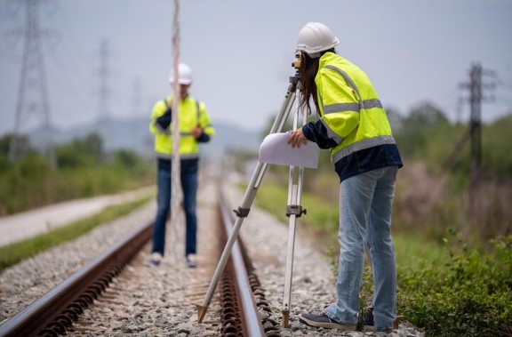
Engineering surveying is an essential aspect of providing safe and reliable infrastructure, which includes rail and water infrastructure. The rail infrastructure surveyors in Australia transform real-world conditions into accurate data, helping project teams make the right decisions that cut down on costs and time. More to the point, rail infrastructure surveyors are concerned with geometry control, asset monitoring, and quality checks to prevent safety problems before they occur.
Thus, expert engineering surveying is highly beneficial for any public transit or water supply project. Accurate measurements and clear communication would enable rail infrastructure surveyors in Australia to be part of risk management from the initial planning phase through to long-term operations.
What is Engineering Surveying and Why Is It Relevant?
Engineering surveying refers to the measurement, mapping, and monitoring of the physical aspects of construction sites. It converts the site conditions into correct coordinates that enable design and construction teams to align the track centerlines, control grades, or plan channel alignments. Given that even small mistakes can pose safety risks or lead to costly rework, quality cannot be compromised.
Specifically, rail infrastructure surveyors in Australia would utilize high-tech equipment, including GNSS receivers, total stations, and laser scanners, to provide well-informed information about the alignment, grade, tidal influence, and hydrographic factors. Also, by combining survey information with model-based digital designs, teams can test assumptions earlier and avoid costly conflicts or unforeseen ground conditions.
Key Areas Where Surveying Reduces Risk
- Alignment and geometry control: The ability to follow accurate track centerlines and curves reduces the risk of defects, derailments, and ongoing maintenance headaches.
- Consistency of elevation and grade: Correct levelling prevents failures in drainage and earthwork, and prevents overloads that lead to embankment breakdown.
- Tidal, hydrographic and geotechnical integration: In waterways, hydraulic models are linked to actual channels, locks and weirs, thereby minimising constructability issues.
- Surveys of infrastructure monitoring provide real-time data on movement, settlement or deformation, which is used to proactively mitigate.
- As-built verification: Surveys conducted after construction confirm that finished works are in accordance with the design, ensuring safety and quality, and providing asset management data.
Rail Infrastructure Surveyors in Australia: A Regional Focus
Diverse topography and high regulatory requirements in Australia’s major territories require local knowledge. Local rail infrastructure surveyors in Australia are aware of local soil conditions, climatic effects and safety needs within states and territories. They build robust control networks, interact with regulators, and inspect construction sites using drones, total stations, and GNSS. Furthermore, by providing clear and consistent information to engineers and project managers, rail infrastructure surveyors in Australia help ensure projects are on time, do not exceed costs, and meet the highest safety standards.
Infrastructure Monitoring Surveys
Infrastructure monitoring surveys are conducted systematically over time to monitor changes in structures, embankments, bridges, and tunnels. Modern equipment Infrastructure monitoring surveys involve remote sensing, vibration and manual measurements of slight shifts or settlement. Indicatively, even the slightest movement in a pier under a bridge may be a sign of foundation issues that need urgent remediation. Infrastructure monitoring surveys provide early detection of trends, enabling a proactive maintenance plan, minimising unforeseen shutdowns, and improving people’s safety.
Civil Infrastructure Surveying: Integrating Design with Asset Management
Sectors encompassed by civil infrastructure surveying include roads, railroads, ports, pipelines, and more. It helps project teams ensure that the design intent and the site reality align, and that the assets built are properly documented.
In addition, this surveying is conducted to ensure that roads, rail, and ports are exactly as planned. Best civil surveying departments record elevations, coordinates, and structural information to produce accurate asset data. As a result, the civil infrastructure survey helps balance costs, allocate resources, and maximise project outcomes from start to finish.
How Surveying Supports Risk Management Across Project Phases?
First, in planning and design, accessing the initial survey data to determine achievable layouts and identify areas of potential impact is carried out early, before the commencement of work. Secondly, during construction and commissioning, verifying in real time and maintaining detailed as-built records prevents rework and helps achieve milestones. In operations and maintenance, continuous monitoring provides performance benchmarks, identifies deterioration, and enables timely interventions. And lastly, as conditions or scope are modified, current survey data enables swift, informed action with minimal disruption.
Why Reliable Data and Clear Communication Matter?
Sound decision-making is based on accurate and timely survey data. With the same updated information, the expectations of all stakeholders, including engineers and operators, will remain on track, and the risk will be visible.
On the other hand, the miscommunication, safety issues or cost increases can be triggered by data gaps or delays. Thus, data quality, calibration records, metadata, and traceability standards should be high.
Best Practice Engineering Surveying of Rail and Water Projects
- Establish a strong level of control early: Define reference points, benchmarks, and data standards before fieldwork.
- Integrate data systems: Connect field measures to design systems, BIM, and asset management solutions.
- Carry out periodic infrastructure surveillance surveys: Conduct periodic examinations to identify movement or deformation patterns.
- Pay attention to the accuracy of civil infrastructure surveying: Design and site data must be kept in sync throughout the project.
- Assure quality and traceability: Have detailed calibration records, metadata and audit trails.
- Promote stakeholder cooperation: Distribute the survey results to engineers, project managers, and operators to coordinate responses to risks.
Choosing The Right Team
The difference lies in the choice of professional, modern equipment and techniques. 2Survey is the most trusted company of survey and engineering with experienced directors. Our firm provides customers with a full-service package, including rail infrastructure surveying in Australia, infrastructure monitoring surveys, civil infrastructure surveying, and more, across the engineering, commercial, industrial, and residential industries.
Conclusion
Engineering surveying provides an effective toolbox for risk reduction in rail and water infrastructure works. Working with experienced rail infrastructure surveyors in Australia will ensure you have the right information for planning, from design through to operation. By making informed decisions based on credible survey data, safer, less expensive infrastructure, and long-term service reliability can be achieved. Collaborate with 2Survey to minimise risk and ensure excellence in each project.