Suppose you purchase a piece of land, design your dream house or a huge factory, then realize that the fence is constructed on the wrong side. It happens more frequently than individuals can think of. This is why land surveyors have become so significant in the Australian property and construction sector.
In 2026, construction regulations are harder than ever before, the cost of land is expensive, and projects are more complicated. Knowledge of a land survey and its price can save time, stress, and money for homeowners, developers and project managers. There are companies such as 2Survey that assist property owners and builders in making reliable and sure choices based on the most accurate and reliable data.
Now, how about simplifying it?
What is Land Surveys?
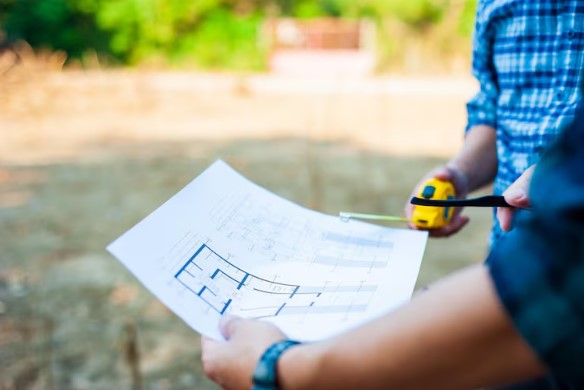
Land survey is the process of accurately measuring and mapping a piece of land to identify its boundaries, features, and physical characteristics. It provides detailed spatial information that helps architects, engineers, and builders plan, design, and construct projects safely and correctly.
Surveyors use specialized instruments and modern technology to capture precise measurements of land. This information is then used to create detailed maps and reports for planning, development, and legal purposes.
It shows:
- Property boundaries.
- Building locations.
- Land levels and slopes.
- Roads, fences, and structures.
- Services like drainage and utilities.
In short, land surveyors collect precise information about a piece of land. This information helps architects to design and plan and builders construct safely.
You are working blind without a survey.
Why are Land Surveys So Important?
Many people think surveys are only needed when buying land. That is not true. Surveys are needed at different stages of property ownership and construction.
- To Confirm Legal Boundaries
A boundary survey ensures you build inside your property lines. This helps avoid disputes with neighbours.
- To Support Development Applications
Councils require survey data before approving construction.
- To Guide Builders
Set-out surveys ensure structures are built in the correct position.
- To Prevent Costly Mistakes
Even small measurement errors can lead to big financial losses.
Professional land surveyors reduce risk and provide peace of mind.
Types of Land Surveying Services in Australia
Surveying is not a one-size-fits-all service. Different projects need different types of surveys.
Boundary & Cadastral Surveys
These surveys define legal property boundaries. This is essential if you are subdividing land or resolving disputes.
In states like Queensland, cadastral surveying QLD must be completed by licensed professionals following strict regulations.
Topographic Surveys
Topographic surveys map land levels, trees, drainage, and surface features. These are needed before designing buildings or roads.
Engineering Survey Melbourne & National Projects
Large infrastructure projects rely on precise engineering data. An Engineering survey Melbourne service supports:
- Road construction.
- Rail projects.
- Bridges.
- Commercial developments.
These surveys ensure designs are correctly transferred to the site.
Industrial Survey
An industrial survey focuses on problematic sites such as factories, plants and large facilities. Precision is important in these environments because machinery alignment and structural accuracy matter greatly.
Construction Set-Out Surveys
These surveys mark the exact position where buildings, walls and structures must be built. Builders depend on engineering surveying services to avoid placement errors.
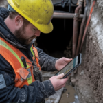
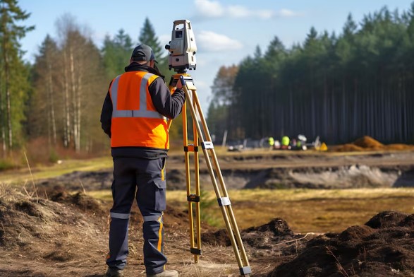
What Do Land Surveyors Actually Do on Site?
When land surveyors get to a property, they do much more than use a tape measure.
The contemporary surveyors operate GPS systems, total stations, laser scanners and occasionally even aerial mapping with drones.
They go into the field and gather some data, after which they process the data with sophisticated software. The final result includes:
- Survey plans.
- Digital CAD files.
- 3D site models.
- Compliance reports.
Professional companies such as the 2Survey collaborate with the latest technology and qualified surveyors to provide very accurate results in Australia.
How Much Does a Land Survey Cost in Australia in 2026?
This is among the most popular questions that property owners raise. But see, the costs vary depending on several factors. Factors that influence survey costs are:
Type of Survey Required
Different types of surveys serve different purposes. A simple boundary check costs less than detailed surveying services or an industrial survey requiring high precision and extended site work.
Size of the Property
Larger properties need more time for measuring and mapping to process. It means more fieldwork, additional equipment setup, and longer data analysis. It naturally increases overall surveying costs.
Terrain Complexity
Flat and open land is quicker to survey. Sloped ground, dense vegetation, obstacles, or built-up areas demand extra effort, specialised tools and more detailed measurements.
Location (Metro vs Regional)
Metro projects usually have higher labor rates. In regional jobs, travel, accommodation, and transport costs may be added. Remote areas require additional planning and logistics.
Level of Detail Needed
Basic surveys cost less than highly detailed mapping. Projects needing 3D models, digital CAD files or compliance documentation require more processing time and expertise.
Urgency of the Job
Tight deadlines may need priority scheduling or extended work hours. Fast-tracked projects cost more due to resource reallocation and increased operational demands.
A small residential block in a flat suburban location will be cheaper than a large industrial location with complex features.
Why Costs Differ Across Australian States?
Surveying regulations differ slightly between states. To illustrate this, look at the example;
- Cadastral surveying in QLD has specific compliance rules.
- Victoria requires registered surveyors for legal boundary work.
- Remote locations may involve travel costs.
Metropolitan regions such as Melbourne and Brisbane can bear higher labour rates, whereas regional projects can come along with added travel and accommodation costs.
How to Choose the Right Land Surveyors?
Not every survey provider provides the same expertise. The following are some of the things to consider when hiring:
- Licensing & Registration: You should always ensure that the surveyor is licensed in your state.
- Experience: Seek experience in projects of the same nature. Engineering and industrial projects would demand expertise.
- Technology: Advanced machinery enhances precision and speed.
- Clear Communication: A good surveyor presents findings in simple language.
- Past Performance: Case studies and project portfolios demonstrate credibility.
Collaboration with specific professionals, such as 2Survey, will guarantee that your project will be served by the team of professionals who are aware of the Australian regulations and construction requirements.
Real-World Applications of Surveying
To appreciate the importance of surveying, we will discuss real-life examples.
Scenario 1: Residential Home Build
A family is planning to construct a new house. A survey was done to establish that their fence was slightly out of line. Early repair will avoid future court hassles.
Scenario 1: Commercial Development
A topographic survey is necessary for the developer before designing a shopping complex. Valid data avoids draining complications.
Scenario 3: Infrastructure Project
Engineering surveying services are used in an engineering team that is undertaking rail upgrades so that tracks are constructed according to the specifications.
Scenario 4: Industrial Expansion
An industrial survey is needed when a manufacturing plant is to be expanded to synchronize heavy machinery and structural supports.
All examples illustrate how land surveyors safeguard investment and mitigate risk.
How Long Does a Land Survey Take?
Survey time depends on complexity.
- Small residential survey: 1-3 days.
- Medium business location: 1 to 2 weeks.
- Major infrastructure project: A few weeks or in progress.
Timelines are also influenced by weather and access, as well as documentation requirements.
Is a Land Survey Worth the Cost?
There are property owners who are hesitant due to the price. But skipping a survey can lead to:
- Boundary disputes
- Construction delays
- Council rejections
- Costly demolition or rebuilds
Survey costs are relatively small compared to total construction budgets.
In 2026, with stricter building compliance and higher land values, surveys are not optional; they are a necessity
The Future of Land Surveying in Australia
The field of surveying is changing rapidly. New technologies may involve drone photogrammetry and 3D laser scanning. We are already on the technology, but we have opportunities to improve. Furthermore, someday, you could come across such technology as digital twins or real-time GPS corrections.
Surveying engineering services are becoming increasingly data-oriented and more precise. This will minimize mistakes and enhance the speed of the projects.
Firms that invest in new technology keep improving the industry standards.
In a Nutshell,
Construction projects are more challenging than ever in 2026. Being accurate is not only useful but is also mandatory.
Safe and successful projects are based on professional land surveyors. Working with experienced specialists protects your investment no matter if you need a simple boundary check or a complex industrial survey.
Act now in case you are considering residential construction, infrastructure or commercial development. 2Survey provides quality surveying services in Australia, supported by state-of-the-art technology and qualified professionals.
Do not leave your project to guesswork! Contact 2Survey today to seek an in-depth quote and make sure your land survey is flawless the first time.
FAQs
What is the difference between a land survey and a cadastral survey?
A property survey is a survey of the property characteristics, whereas a cadastral survey is a legally defined boundary that is measured.
Do I legally need land surveyors?
For boundary and subdivision work, yes. Licensed professionals are needed.
How accurate are modern surveys?
Modern equipment allows measurements within millimetres, especially for engineering projects.
Can survey costs increase?
Yes, if unexpected site conditions or extra reporting requirements arise.
How do I get a quote?
Most professional firms offer detailed project-based quotes after reviewing site information.