In Australian land development, a tiny measurement error can trigger a massive legal domino effect. While most see Cadastral Surveys as a “check-box” legal requirement, smart developers know it’s actually a strategic shield. It is the difference between a project that sails through Council and one that gets buried in redesigns and neighbor disputes.
With planning approvals now averaging 38 months, accurate cadastral data is your best defense against bureaucratic delays.
Let’s reveal how precise land data doesn’t just define your dirt; but protects your ROI and unlocks the fast-track to title registration.
What is a Cadastral Survey?
A Cadastral Survey is a legally regulated land survey used to define property boundaries, ownership rights, and land divisions. In Australia, these are mandatory for creating new land titles, securing development approvals (DA), and resolving boundary disputes.
At a glance, it allows you to:
Verify exact property dimensions: Precise measurements eliminate boundary ambiguity by reconciling historical title data with high-accuracy field observations. This technical rigour ensures that every millimeter of your land is legally accounted for and protected.
Secure faster approvals: Certified plans ensure compliance, slashing council delays. In Victoria, accurate data unlocks the Small Lot Housing Code’s fast-track approvals for lots under 300sqm, significantly accelerating your project’s legal registration.
Mitigate legal disputes: Accurate cadastral data provides a definitive legal “shield” against potential encroachment claims from neighboring owners. Establishing clear boundaries from the outset avoids expensive litigation and maintains project security.
Why Cadastral Surveys Matter More in Australia?
Australia’s land title systems are among the most precise in the world. Whether you are dealing with Torrens Title in Victoria or specific Crown Land considerations in the Northern Territory, compliance is not optional.
Without a certified Cadastral Survey, your project faces:
Council Rejection: Incomplete data triggers official requests for further information, stalling your project. These delays increase holding costs and postpone your construction start date.
Encroachment Risks: Building over a boundary can trigger legal disputes or mandatory demolition orders. Precise surveys ensure every structure sits safely within legal property limits.
Title Deadlocks: You cannot legally sell or settle lots without a registered Plan of Subdivision. A certified survey is the only way to unlock these individual land titles.
This is why developers utilize specialized surveyors in Melbourne, Victoria for high-density urban infills, complex regional and topographical layouts.
2Survey Advantage: 5 Ways Cadastral Data Protects Your ROI
1. Eliminating “Invisible” Risks
Boundary confusion is a silent project killer. By legally defining boundaries early, you eliminate the risk of misaligned infrastructure or “building on the wrong side of the fence.” In high-value areas like Melbourne, Victoria, where every square meter counts, this precision is worth thousands in saved litigation costs.
2. Accelerating Approval Timelines
Time is development money. Councils prioritize submissions that include clear, certified surveying documentation. Working with experienced engineering surveyors in Victoria ensures your data meets local standards the first time, cutting weeks off the approval loop.
3. Maximizing Land Efficiency
A survey isn’t just a map; it’s a planning tool. Accurate data allows for better lot placement and easement management.
Pro Tip: Integrating cadastral data with a Mining survey or topographic scan provides a 3D understanding of the land. This allows surveyors in Alice Springs and regional Victoria to help you avoid rocky terrain or unstable ground before you even break ground.
4. Legal Protection and Compliance
A Cadastral Survey provides an official, permanent record with the State Land Registry. This provides a “legal shield” that adds massive value to the property during the sale process, giving buyers total confidence in what they are purchasing.
5. Seamless Infrastructure & Utility Alignment
From drainage systems to road access, every utility depends on the boundary. We ensure your utilities are installed exactly where they are legally permitted, preventing costly rework during construction.
2Survey Process: From Field to Title
- Historical Research
We investigate land titles and ancient survey records to uncover original boundaries. This deep dive ensures your project rests on a verified legal foundation.
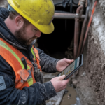
- Advanced Field Measurement
Our team uses satellite GPS and laser-scanning tools to map every centimeter of your site. These high-tech measurements eliminate human error and ensure absolute physical accuracy.
- Digital Processing
We convert raw field data into sophisticated digital models compatible with your architect’s software. This seamless integration allows for perfect design alignment before any ground is broken.
- Legal Lodgment
We certify the final plans and manage the complex submission process to government land registries. This official step secures your new titles and makes your development legally official.
Why Partner with 2Survey Pty Ltd?
Since 2016, 2Survey has provided end-to-end surveying solutions across Australia. We bridge the gap between technical precision and commercial reality.
- 25+ Years of Leadership: Our directors bring decades of combined experience to every site.
- National Footprint: Expertise in both metro and regional locations in Australia.
- Comprehensive Service: From initial boundary checks to complex engineering and mining surveys.
Get It Right from the Ground Up
A Cadastral Survey is the make-or-break factor for subdivisions in Australia!
Don’t let a boundary error derail your project. Whether you’re planning a two-lot subdivision or a large-scale infrastructure project, 2Survey provides the accuracy you need to build with confidence.
Contact 2Survey today for a preliminary project assessment!
FAQs
Do I need Cadastral Surveys before subdivision?
Yes, they are mandatory for legal land division and council approval in Australia.
What happens if property boundaries are wrong?
You may face legal disputes, project delays, or costly reconstruction.
Are Cadastral Surveys different from engineering surveys?
Yes. Cadastral Surveys focus on legal boundaries, while engineering surveys focus on design and construction data.
Can Cadastral Surveys be used with Mining survey services?
Absolutely. Combining both provides a complete understanding of land boundaries and terrain.