Hiring the wrong land surveyors can cost you time, money, and legal headaches. The right one keeps your project on track from the first peg in the ground to final sign-off. Before you bring anyone on board, these are the seven questions every property owner, developer, or contractor in Australia should be asking. A formal QA process is essential for legal and structural compliance.
Quick Guide: Before hiring a land surveyor in Australia, ensure they are licensed in your state, possess sector-specific experience (e.g., mining or civil), and utilise modern tech such as drone/laser scanning.
Here are some things you need to keep in mind while hiring a land surveyor:
1. Are They Licensed and Registered in Your State or Territory?
This is the non-negotiable starting point. In Australia, land surveyors must hold a current licence issued by the relevant state or territory authority. It is not enough to be experienced; they need to be legally authorised to practise in your jurisdiction. Always ask to see their registration number and verify it with the licensing body.
At 2Survey, our surveyors aren’t just registered; we are strictly compliant with the Surveying Act 2004 and the new CPD Guidelines 2026. With the recent updates to the Transfer of Land (Fees) Regulations 2026 in April, having a team that understands the evolving fee structures in Victoria is vital for accurate project budgeting.
2. Do They Have Experience with Your Type of Project?
Surveying covers a broad range of work. A professional who excels at residential boundary surveys may not have the depth of knowledge needed for mining project surveying or large-scale civil infrastructure. Ask directly about their experience in your project category.
For example, Mining project surveying requires an understanding of earthworks volumes, blast zone setouts, and ongoing monitoring; skills that are quite different from a standard subdivision job. Ask for case studies or references from similar projects.
We ensure our mine surveyors hold the current credentials required to manage survey plans under the latest WHS (Mines) Regulations, preventing costly compliance shutdowns for your site.
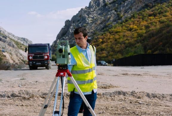
3. What Survey Methods and Technology Do They Use?
The equipment and methods a surveyor uses directly affect the accuracy and efficiency of your data. Traditional total stations and GPS still have their place, but modern projects often require more. Ask whether they offer drone and laser scanning surveys.
Drone and laser-scanning surveys can capture millions of data points across large areas in a fraction of the time it takes ground-based methods. For complex terrains, tight timelines, or hard-to-access sites, this technology is not a bonus; it is often essential.
Ask specifically: do they own the equipment or subcontract it? Firms that own and operate their own drone and laser-scanning survey capabilities tend to have tighter quality control and faster turnaround.
4. Can They Handle Topographic Surveying for Your Site?
Topographic surveying is one of the most frequently requested services in development and construction, and one of the most misunderstood. It captures the land’s shape: levels, contours, drainage patterns, existing structures, and services.
Good topographic surveying gives your engineers and architects the data they need to design accurately from day one. Poor topographic data leads to re-design, disputes between trades, and cost blowouts mid-construction.
Ask how they capture and deliver topographic data. Do they provide CAD files, GIS layers, or just a basic plan? The format of their deliverable matters as much as the accuracy of the survey itself. Experienced land surveyors will discuss deliverable formats without hesitation.
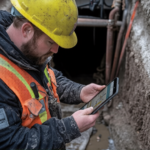
5. Do the Surveyors Offer Engineering Surveyor Support On-Site?
Construction projects do not stop needing surveying input once the initial plan is done. Engineering surveyors are needed throughout the build for setout, verification of earthwork and structural positions, and as-built documentation at completion.
Engineering surveyors work directly with site teams, translating designs from the model to the ground. Without this, costly mistakes can only be identified after concrete has been poured or steelwork is in place.
Ask whether their engineering surveyors are available for ongoing site attendance, not just a one-off visit. Continuity on site reduces errors and keeps compliance documentation clean throughout the project lifecycle.
6. How Do They Handle Survey Management on Complex Projects?
On large or multi-stage projects, surveying is not just a single task; it is an ongoing discipline that needs to be managed. Poor coordination between land surveyors working across different parts of a site can lead to misaligned work fronts and expensive rework.
Ask how they structure survey management. Do they establish and maintain a site control network? How do they validate data before using it on-site? Do they coordinate with other disciplines to prevent clashes?
Strong survey management keeps all contractors working from verified, consistent data. It is particularly critical on infrastructure projects where multiple land surveyors or subcontractors may be working simultaneously.
7. What Does Their QA Process Look Like?
Even experienced land surveyors can make mistakes, but reliable ones have systems to catch them before they become your problem. Ask about their quality assurance process: how do they check their own work?
A good QA process includes independent checks on field data before delivery, clear documentation trails, and structured sign-off at each project stage. Ask whether they provide as-built QA documentation at completion; this is often a contractual requirement on commercial and civil projects.
Land surveyors with no formal QA process are relying on individual care rather than a system. On a project where a one-centimetre error can have significant legal or structural consequences, that is not good enough.
One More Thing: Do They Communicate Clearly?
This sounds obvious, but it is regularly overlooked. The best land surveyors are only valuable if they can communicate their findings clearly, promptly, and in a format your project team can act on.
From the initial brief through to final documentation, you want a team that keeps you informed without needing to be chased.
2Survey sets the national standard for communication through a “Proactive-First” approach. Rather than waiting for a client to ask for an update, we provide:
- Dedicated Single Point of Contact: You aren’t passed back and forth between departments. Your project is managed by a senior surveyor who understands your specific site constraints.
- Live Data Access: On large-scale projects, we utilize cloud-based portals that allow architects and engineers to access drone and laser-scanning data as soon as it’s processed, eliminating the “waiting game.”
- Structured Reporting: Whether it’s a boundary dispute under the Victoria Transfer of Land Act or a complex mining setout, our team delivers reports that are jargon-free and structured for immediate legal or engineering sign-off.
2026 Compliance Quick-Check:
- Licensing: Ensure compliance with VIC CPD Guidelines 2026 and the Surveying Act.
- Mining: All surveyors must now hold the Mining Statutory Position Certification (effective March 2026).
- Tech: Use GNSS standards compliant with the May 2025 NT Board Code.
Final Wording:
Choosing the right land surveyor shapes the accuracy and efficiency of everything that follows. Whether your project calls for topographic surveying, mining project surveying, specialist engineering surveyors, or drone and laser scanning surveys, the team you hire needs to be licensed, experienced, technically up to date, and easy to work with.
2Survey brings all of that together. Our licensed land surveyors operate across Victoria and the Northern Territory, delivering cadastral, boundary, construction setout, and site management services with precision and accountability on every project.
You deserve land surveyors whom you can rely on. Contact 2Survey now!
FAQs
Do I need a land surveyor to build a fence?
Yes. To avoid legal disputes, a licensed land surveyor should perform a Title Boundary Survey. Relying on old pegs or existing structures is risky; in Victoria and the NT, only a licensed surveyor can legally define a boundary to protect you from future encroachments.
What is the difference between a land surveyor and an engineering surveyor?
A land surveyor (often licensed/cadastral) is legally authorised to define property boundaries and land titles. An engineering surveyor works on the construction side, translating architectural designs onto the physical ground and managing earthworks, setouts, and structural alignments during the build.
How long is a topographic survey valid for in 2026?
Most Australian councils (like Brisbane or Sydney) and planning authorities now require topographic surveys to be less than 24 months old. This ensures that any recent site changes, such as drainage shifts, new vegetation, or neighboring construction, are accurately reflected in your development application.
Are drone surveys as accurate as ground surveys?
Modern drone and LiDAR (laser-scanning) surveys can achieve vertical accuracy of 2–5cm. While traditional ground-based GPS is still used for high-precision boundary pegs, drones are the 2026 gold standard for quickly capturing millions of data points across complex terrain or large mining sites.
What is a “Mining Statutory Position” for surveyors?
As of March 30, 2026, all mine surveyors in Australia must hold a Mining Statutory Position Certification. This ensures that the surveyor is legally qualified to manage mine survey plans and safety protocols in accordance with the latest WHS (Mines) Regulations.