Engineering surveying has advanced significantly in the current high-paced construction and infrastructure world, as much as it has in measuring angles and distances. It has become all about accuracy, digital innovation, and efficiency—the foundation of every modern project. More innovative technologies, tools, and fact-based decision-making are transforming the future of engineering surveying, driven by the rise of high-rise buildings and complex infrastructure networks.
We should take a closer look at how this crucial discipline is transforming and at the tendencies shaping its further development.
What Is Engineering Surveying?
In its simplest form, engineering surveying is the accurate measurement and mapping of land to aid in planning, designing, and building infrastructure. It ensures that all elements — bridges, highways, and buildings — are constructed in the precise locations where they are supposed to be, to the exact specifications.
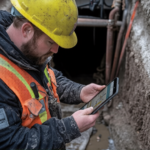
Today, the engineering surveyor is more than a field technician; he/she is an expert in data, a user of technology, and a project strategist who is key at all stages of a project, including set-out survey services for construction and infrastructure monitoring surveys, working alongside professionals such as surveyors Melbourne on major developments across Australia.
The Change to Intelligent Surveying
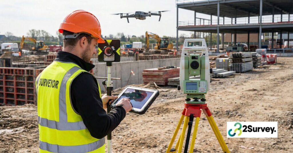
The days of manual measurements and paper maps are gone. Nowadays, surveying in engineering is a field of innovation. Drones, 3D laser scanning, GPS-based surveying, and real-time data processing technologies have completely transformed the surveyor’s work.
These innovations have not only made surveys more accurate but also safer, faster, and cheaper. Digital tools can enable teams to work with confidence, even in the most complex settings, by minimizing manual work and maximizing accuracy.
Technology at the Helm of the Change.

1. Drones and Aerial Mapping
Unmanned Aerial Vehicles (UAVs), or drones, have become an essential part of contemporary surveying. They can travel great distances in a very short time and record high-resolution images and 3D information that would otherwise take days to collect manually.
In construction set-out survey services, drones have provided a bird’s-eye view of the project site, enabling surveyors to map the terrain, track progress, and detect problems before they become costly failures.
2. 3D Laser Scanning
Another game-changer is 3D laser scanning (LiDAR). It enables surveyors to create highly realistic digital models of environments—including all slopes, contours, and features — with point-precise accuracy. These digital models are invaluable in infrastructure monitoring surveys, as they help identify changes or deformations in structures at an early stage.
3. GPS and GNSS Technology
Positioning systems such as GPS and GNSS Satellites have elevated the standard of precision to a new level. Surveyors in the engineering profession can now gather geospatial information on-site, making surveying construction set-outs and project setup unquestionable.
This technology also supports remote data collection and thus the coordination of teams working across various locations.
4. BIM Integration (Building Information Modeling)
Surveying engineering is increasingly integrated with BIM, a digital model of a project’s physical and operational data. Combining survey data with BIM systems will allow architects, engineers, and contractors to visualize their projects in real time and make changes immediately.
This integration reduces the human factor, enhances communication, and the physical build fits perfectly with what was designed on the computer.
Information: The New Foundation of Engineering Surveying.
Data is ubiquitous in the contemporary world, and engineering surveying is no exception. There are now petabytes of geospatial and environmental data in surveyors’ hands, enabling more intelligent decision-making.
With advanced data analytics, surveyors will be able to anticipate potential issues, design more efficient methods, and improve safety on construction sites. Be it determining soil instability or structural health, data-driven surveying is guaranteed to be reliable and sustainable in the long run.
Sustainability and Smart Infrastructure.
Sustainability is another trend increasing in engineering surveying. As the world turns its focus to green construction, surveyors are playing a key role in reducing environmental impact.
Surveyors conduct infrastructure monitoring surveys to evaluate the interaction of structures with the environment, including ground movements, water levels, and changing environmental features. This helps ensure that projects are not only efficient but also green.
Moreover, the development of renewable energy facilities, including solar farms and wind turbine projects, cannot be successfully implemented without engineering surveying.
The Importance of Construction Set-Out Survey Services.
Everything in construction is accurate. A minor deviation can cause costly remedies in the future. That is where construction set out survey services are involved.
These services also convert design plans into actual coordinates so that foundations, walls, utilities, and other structural components are placed in the exact positions. Modern set-out surveys are providing unprecedented accuracy with technologies such as robotic total stations and digital mapping, helping contractors finish projects on schedule and on budget.
Professional set-out surveys are good news for developers and project managers: confirmation that the design vision is realized and perfected on the ground.
Infrastructure Monitoring Surveys Role.
When a project is finished, the job of an engineering surveyor does not end with that. Surveys conducted in infrastructure monitoring help ensure the continued safety and performance of structures.
The sensors, LiDAR, and GPS tracking allow surveyors to detect the slightest shifts or structural rotation. This information is crucial to the maintenance staff so they can address potential problems before they escalate. It could be a bridge under constant traffic pressure or a high-rise exposed to high winds, but frequent monitoring is one way to prolong its life and maintain people’s safety.
The Future Is Digital, Connected, and Automated.
In the future, automation, connectivity, and artificial intelligence will determine the next phase of engineering surveying. Connected ecosystems that leverage smart sensors, cloud-based data storage, and real-time analytics are creating an environment where each bit of data flows into more intelligent project management.
In the near future, AI-controlled surveying tools can analyze large volumes of data independently, detect trends, and predict problems before they occur. The process is also being augmented with augmented reality (AR) and virtual reality (VR) technology, enabling engineers to visualize structures before construction.
These innovations will not only improve the accuracy of the same but also minimize risks and costs, making the survey process more efficient than ever before.
Collaboration with Experts You Can Relax.
In a world where precision and speed are the primary determinants of success, it is essential to work with professionals who know the future of surveying. Companies like 2Survey
We are at the forefront, providing high-end engineering surveying, construction set-out surveying, and infrastructure monitoring services that are both precise and innovative.
They are highly qualified and employ the latest technology, so their projects, regardless of size, are built on a foundation of reliability and accuracy. Don’t think much contact us today!
Frequently Asked Questions
Engineering surveying measures and maps land so structures are built in the right place and to the correct design. It’s essential for planning, set-outs, safety, and long-term performance.
Drones capture high-resolution images and terrain data quickly, helping surveyors map sites, monitor progress, and detect issues much faster than manual methods.
3D laser scanning (LiDAR) creates accurate digital models of buildings and terrain. It helps detect structural changes early and supports precise design and monitoring.
BIM integrates real survey data into a digital model so engineers and builders can see the project clearly, make updates fast, and avoid errors during construction.
A licensed surveyor defines legal boundaries, prepares certified plans, checks compliance, and ensures construction elements are correctly positioned on-site