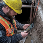
In construction, civil engineering, and other massive-scale infrastructure projects, precision and effectiveness can make or break. However, a lot of corporations do not fully realize the extent to which professional survey management services can cut down on workloads, minimize expensive mistakes, and provide you with data that you can rely on.
Have you ever had to deal with project delays, misalignments, or data inconsistency? There is a high probability that you need to upgrade your survey process. The good news? Professional tools, such as total surveying services from 2Survey, can help you turn complex fieldwork into actionable insights.
Why Survey management is the key to brilliant project execution – and what your business is potentially missing out on.
What are Survey Management Services, and what are the reasons?
Survey management services include planning, data collection, analysis, reporting, and delivery. These services are used in the construction industry, civil works, and infrastructure development to make decisions based on accurate ground data, including detailed industrial surveying services that support design, layout, and construction accuracy.
Rather than balancing various tools, teams, and data sources, an expert survey management partner, such as 2Survey, takes on the coordination of the entire process, ensuring accuracy, compliance, and efficiency at every step. Proper land records and boundary verification through cadastral survey work also help ensure projects meet legal and regulatory requirements..
The Ulterior Perquisites of Professional Survey Management Services.
Higher Accuracy, Lower Risk
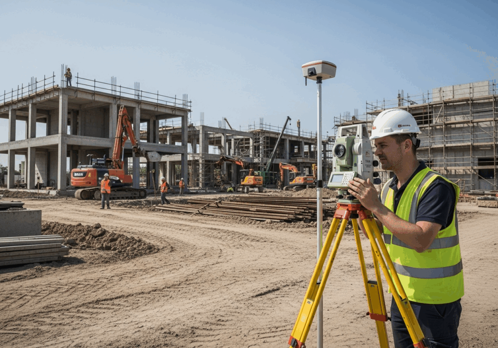
Precision matters. In GPS-based station setup surveying, 2Survey guarantees maximum measurement accuracy for each data point. This level of detail reduces rework, increases safety, and ensures your designs are carried out as intended.
Smarter Data Preparation
Surveying does not only involve collecting data, but also making sense of it. Digitizing raw data for design and modelling, 2Survey assists in preparing data for use in civil projects. This saves hours and eliminates errors in project handover.
Dependable Set Outs of Construction.
The data preparation for civil projects most precise and directly affects the quality and progress of your project. 2Survey guarantees an expert professional team that will ensure your structures are placed exactly as per the construction specifications and minimize the risk of misalignment and errors during construction.
Relaxation with Scrutiny and Quality Control.
In large-scale infrastructure or civil projects, industry standards cannot be negotiated when preparing documentation, and 2Survey offers experienced individuals who can ensure full compliance with local and national standards during surveys.
Fundamental Services 2Survey provides.
In 2Survey, the business provides end-to-end surveying solutions to current construction and civil engineering issues. Their primary services take the following shape:
1. Survey Management Services
From the planning stage through the final project, 2Survey provides complete survey management. This involves scheduling, coordinating fieldwork, analyzing data, and reporting. They aim to ensure that your project is operational— with precise data to guide the process.
2. Setting up GPS Base Station Surveying.
Precision begins at the base—physically. 2Survey provides GPS-based base-station surveying services to establish well-established geospatial control networks. This provides a guarantee that any other survey work and construction alignments on the site should be consistent in accuracy.
3. Construction Set Out Survey.
Regardless of the type of construction (commercial complex or community-based infrastructure project), the construction set-out surveys provided by 2Survey ensure that all elements of the building, from foundations to utilities, are laid out in the exact positions as proposed. The precision of their operations and the use of modern equipment ensure they are pinpoint accurate and that on-site discrepancies are minimal.
4. Preparation of Data in Civil Projects.
Data preparation in civil projects is an integral part of the success of any civil project, and the data preparation for a 2Survey of civil projects makes all field data ready for processing and formatting for integration into design software. This streamlines the process among surveyors, engineers, and contractors.
5. UAV and Drone Surveys
Aerial insights are very beneficial to modern projects. 2Survey is a drone technology that has been applied to mapping, terrain modelling, and volume computation to enable fast, safe data collection, even on challenging routes.
6. 3D Laser Scanning
In projects that require detailed information, 3D laser scanning provides high-quality, high-point-density point cloud data. This assists architects and engineers in visualizing the structures, tracking progress, and making modifications.
7. Volume and As-Built Surveys
2 Survey also focuses on volume survey to determine the amount of material and an as-built survey to check that the finished work conforms to the initial design requirements —highly crucial to documentation and compliance.
Why 2Survey to Your Survey Management Requirements?
The difference is that 2Survey combines innovative technology, qualified specialists and customer-oriented solutions.
They not only present data in their team but also provide clarity. They make sophisticated field data usable for drones, provide complete datasets, and deploy digital processing technology that saves time and reduces guesswork, working alongside trusted professionals such as surveyors Melbourne when projects require extended regional expertise.
The benefits of collaborating with them are:
-
- Availability of state-of-the-art equipment and software.
-
- Accomplished surveyors who are a good fit.
-
- Project management: from data capture to reporting.
-
- White label and customizable service solutions to suit your project scope and budget.
-
- Open communication and response time.
Essentially, 2Survey is a kind of extension of your project team, in which your survey data is not only correct but meaningful as well.
The Bottom Line: Do Not Let the Competitive Edge Pass by.
The use of old-fashioned, manual surveying is an aspect you cannot afford to risk in the fast-paced construction and civil industry. Proper surveys lead to superior designs, expedited approvals, and risk-free construction, all of which translate into successful project outcomes.
By investing in reliable survey management services from a partner like 2Survey, your company will gain the accuracy, speed, and confidence needed to deliver all projects on time and within budget.
Ready to Elevate Your Surveying Process?Stop guessing and start building with confidence.
Contact 2Survey today to learn how their survey management services, construction set-out surveys, and GPS base-station setup surveying can take your next project to the next level.
Your data deserves to work as hard as you do — and with 2Survey, it will.
Frequently Asked Questions
1. What are survey management services?
Survey management services cover planning, fieldwork, data collection, analysis, and reporting to ensure accurate and reliable survey results for construction and civil projects.
2. Why do construction projects need professional set-out surveys?
Set-out surveys make sure foundations, utilities, and structures are placed exactly where the design specifies, reducing errors, delays, and rework.
3. How do GPS base-station surveys improve accuracy?
A GPS base station creates a stable control network on-site, helping all survey measurements stay consistent and precise throughout the project.
4. What is the benefit of drone or UAV surveying?
Drone surveys collect aerial data quickly and safely, giving clear insights for mapping, terrain modelling, and progress tracking without interrupting site work.
5. What does a licensed surveyor do?
A licensed surveyor handles legally certified tasks like boundary checks, compliance documents, and verifying that construction work meets design and regulatory standards.