Imagine turning a dusty, overgrown plot into a bustling neighbourhood or a state-of-the-art logistics hub!
Without land development surveyors in Australia, it would be absolute chaos!
In 2026, these professionals use cutting-edge technologies such as drones, AI, and digital twins to make development seamless and sustainable. High-density land surveyors in Alice Springs and engineering survey experts ensure that every boundary and building is accurate and error-free.
This guide breaks it down simply: who they are, what they do, and why they are game-changers for projects big and small.
What Are Land Development Surveyors in Australia?
In other words, land development surveyors in Australia are licensed experts who measure, map, and manage the development of land. By 2026, these surveyors will have come a long way since the days of stakes and hammers. Today, they use GPS-RTK technology, terrestrial laser scanning, cloud data sharing, and more to ensure millimetre accuracy.
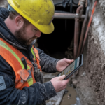
Land development surveyors are experts who perform all tasks related to small residential subdivisions or skyscrapers.
For example, land surveyors in Alice Springs must conduct surveys across vast outback areas. The environment is challenging for them, but the accuracy is always perfect. Similarly, development surveyors for land must conduct surveys for residents of Melbourne. The tasks include surveys of skyscrapers, industrial surveys of large factory floors, and specialised engineering surveys of bridges and highways in Victoria.
The common services performed by development surveyors for land are:
- Cadastral Surveys: Measuring and defining the boundaries of land.
- Topographic Surveys: Creating 3D models of the site’s natural and man-made features.
- Construction Setouts: Exactly marking the spot where buildings are to be constructed.
- As-Constructed Surveys: Verifying that the final construction is correct according to the initial design.
One can imagine land development surveyors in Australia using automated drones to perform their tasks over the Red Centre. Development surveyors for land are now using automated drones to perform their tasks in Alice Springs 10 times faster than before.
However, their tasks are not only related to the above-mentioned services but also follow a specific process.
Daily Workflow of Land Development Surveyors in Australia
In 2026, the surveying process was streamlined through automation and high-speed data. Here is the typical five-step workflow for modern projects:
- Site Reconnaissance and Research: Before hitting the field, land development surveyors in Australia assess risks such as flood zones and heritage overlays using satellite imagery.
- Advanced Data Collection: Using drones and robotic total stations, the team gathers spatial data. Land surveyors in Alice Springs often use satellite-linked tech for remote connectivity, while surveyors in Melbourne integrate urban BIM (Building Information Modelling) for vertical accuracy.
- Data Processing and AI Analysis: AI algorithms clean the raw data, removing “noise” like traffic or vegetation. This is vital in industrial surveying for large warehouses and for an engineering survey in Victoria related to new road interchanges.
- Reporting and Compliance: Modern surveyors produce legal documents that are instantly compliant with state land titles offices.
- On-Site Setout: This is the “boots on the ground” phase, where they mark the exact position for foundations.
Let’s zoom in on some key specialties that keep our economy moving.
Key Specialties: From Industrial Surveying to Urban Projects
Industrial Surveying in Action
Industrial surveying powers the heart of our commerce: factories, warehouses, and energy plants. In these environments, precision is non-negotiable because machinery must fit into pre-designed spaces with zero margin for error. Land development surveyors in Australia lead the way here, ensuring safe and efficient layouts. When dealing with mining or large-scale energy hubs, land surveyors in Alice Springs handle remote industrial sites with incredible resilience. In contrast, surveyors in Melbourne focus on expanding suburban logistics parks.
Engineering Survey in Victoria Spotlight
On the other hand, an engineering survey in Victoria supports the massive infrastructure projects that connect our cities. Land development surveyors in Australia excel in this niche, partnering with civil engineers on roads, tunnels, and rails. Because Victoria has a diverse geography, from coastal plains to alpine regions, these surveys are critical for structural integrity.
Key benefits of specialised surveying include:
- Significant reduction in rework costs.
- Compliance with strict ISO safety standards.
- Enhanced coordination between architects and builders.
For example, regional versus metropolitan work varies hugely in terms of environmental challenges.
Regional Spotlights: Land Surveyors in Alice Springs vs. Melbourne
The contrast between the Red Centre and the “Garden City” highlights the profession’s versatility.
- Land Surveyors in Alice Springs: These professionals work across vast terrain and extreme temperatures. Their work is often drone-heavy, focusing on mining, large-scale pastoral subdivisions, or desert industrial surveying.
- Surveyors in Melbourne: They operate in high-density environments where every centimetre counts. Their focus is often on high-rise offsets, complex strata titles, and the high-stakes world of engineering survey in Victoria.
Interestingly, development surveyors for land in Australia adapt seamlessly to both. Land surveyors in Alice Springs might battle dust storms and connectivity gaps. In contrast, surveyors in Melbourne dodge heavy traffic and navigate complex underground utility networks.
So, what specific tools are shaping this profession in 2026?
Tech Transforming Land Development Surveyors in Australia in 2026
The future is here. Digital twins, AI analytics, and LiDAR (Light Detection and Ranging) are now standard.
Land development surveyors in Australia integrate these tools to ensure a quick turnaround of information. For example, handheld LiDAR scanners are currently used in modern industrial surveying to scan factory interiors in minutes.
Equally, a modern engineering survey of Victoria would consider the use of VR (Virtual Reality) previews, allowing project managers to explore a site even before a single brick is laid. The development surveyors for land in Australia have therefore become the custodians of project data.
Challenges and Solutions for Modern Surveyors
Even with the best tech, challenges exist. Tight deadlines and evolving environmental regulations require constant vigilance. Strict deadlines and a changing environmental policy demand round-the-clock attentiveness.
To address this, land development surveyors in Australia have used cloud collaboration, enabling field data to be made visible to teams in the office.
Whether it is a land title dispute or a complex construction alignment, they stay compliant with the latest Australian standards to ensure peace of mind for developers.
Why Land Development Surveyors in Australia Matter in 2026?
From the initial boundary peg to the final height check on a skyscraper, these experts are the backbone of the construction industry. From the initial boundary peg to the final height check on a skyscraper, these experts are the backbone of the construction industry. Whether it is industrial surveying for international logistics companies or an engineering survey in Victoria for a local council bridge, they maintain the accuracy that allows Australia to continue construction safely.
That’s where 2Survey shines!
Your reliable companions in Land surveying services in Australia with licensed professionals in Victoria and the Northern Territory. We have been conducting cadastral surveys, site setouts, and topographic surveys of works throughout the country, with dedicated land surveyors in Alice Springs and Melbourne. We excel in both industrial surveying and complex engineering survey in Victoria, offering boundary surveys, subdivisions, and modern spatial mapping tailored to 2026 standards.
Moreover, we prefer to specialise in practical expertise. We develop site controls, lay out structures, and produce extensive QA documentation to help you prevent costly rework. Operating in Melbourne, Victoria statewide, Alice Springs, Darwin, and beyond, our Survey Management Services keep complex projects on track; think cadastral survey and industrial surveying without clashes.
Takeaway
As leading land development surveyors in Australia, we provide your project with the legal and spatial assurance it deserves.
Ready to start your next development with confidence?
Get a quote today! Contact 2Survey for precise, compliant solutions that meet your tightest deadlines.
Frequently Asked Questions:
What does a land development surveyor do in Australia?
Land development surveyors measure, map, and manage land for construction and development projects. They define boundaries, create site plans, and ensure all work complies with legal and regulatory standards.
Do I need a land development surveyor before starting construction?
Yes, hiring a surveyor is essential before construction. They provide accurate data for planning, help secure council approvals, and ensure buildings are positioned correctly to avoid costly mistakes.
What is the difference between cadastral and topographic surveys?
Cadastral surveys define legal property boundaries, while topographic surveys map land features such as slopes, trees, and structures to support design and planning.
What technology do modern surveyors use in 2026?
Surveyors use advanced tools like GPS-RTK systems, drones, LiDAR scanners, AI data processing, and digital twins to achieve high accuracy and faster project delivery.
Why are land surveyors important for industrial and engineering projects?
They ensure precise alignment of structures and machinery, reduce construction errors, and help maintain safety and compliance in complex environments.
How do I choose the right land surveyor in Australia?
Look for licensed professionals with relevant experience, modern technology, strong project portfolios, and clear communication—like the expert team at 2Survey.
How much do land development surveyors cost in Australia in 2026?
The cost of hiring a land development surveyor in Australia depends on several factors, including the size of the property, type of survey required, site complexity, location (metro or remote), level of detail needed, and project urgency. More complex or large-scale projects typically require additional time, advanced technology, and detailed reporting, which can increase overall costs.