Mining has always been about precision — every meter matters when millions of dollars are invested underground. But what often goes unnoticed is the quiet force behind every successful mine: mining project surveying. Over the years, this essential discipline has evolved from simple hand tools to advanced drone mapping systems, redefining how mining operations are planned, executed, and monitored across Australia.
Innovation at 2Survey combines technology and knowledge to provide next-generation surveying solutions for mining projects that enhance efficiency, safety, and accuracy in one of the most challenging industries in the world.
The Childhood Years: Compass, Chain and Courage
Australian mining surveyors used to explore extensive remote mining regions with simple tools such as compasses, chains, and theodolites. These pioneers had to work under challenging conditions — erratic weather and poor visibility —, but their survey provided the basis for some of the largest mining ventures in Australia.
The time needed to survey was marked by great skill, intuition, and manual calculation. Mistakes may indicate misaligned shafts or ineffective resource extraction. Nevertheless, these pioneers laid the foundation for an industry that would later evolve into a highly technologically advanced field in contemporary engineering.
The Majority of Precision: Precision Engineering Surveying Replaces
With the growth of mining in Western Australia and Queensland, the need for accuracy increased. It is at this time that engineering surveying in Australia began to transform the industry. Rudimentary tools such as the compass were replaced by more sophisticated instruments, such as total stations and GPS receivers, that provide centimeter precision.
Mining companies began to depend heavily on engineering surveyors to design access roads, pit arrangements, and underground tunnels. This change was not only more efficient but also introduced a digital method of data collection, the first significant step toward the modern, innovative surveying system.
At this point, mining surveys were no longer concerned with measuring land, but with strategic planning—ensuring that all operations could be optimized in terms of performance, safety, and sustainability.
The Digital Age: Software, Data and Satellites
By the early 2000s, mining project surveying had undergone a complete transformation due to technological advances. Use of satellite positioning systems and computer-aided design (CAD) became the norm. The surveyors were now able to gather, process, and model terrain data in real time to produce precise digital twins of entire mine sites.
It is also at this time that mining surveyors in Australia started adopting Geographic Information Systems (GIS) into their operations. GIS and GPS have enabled geologic analysis, excavation route planning, and the tracking of environmental impacts with unparalleled precision.
Surveyors in modern mining have become experts in data analysis, processing large amounts of information to guide decisions that will make a project profitable.
Drones and Automation: The New Frontier
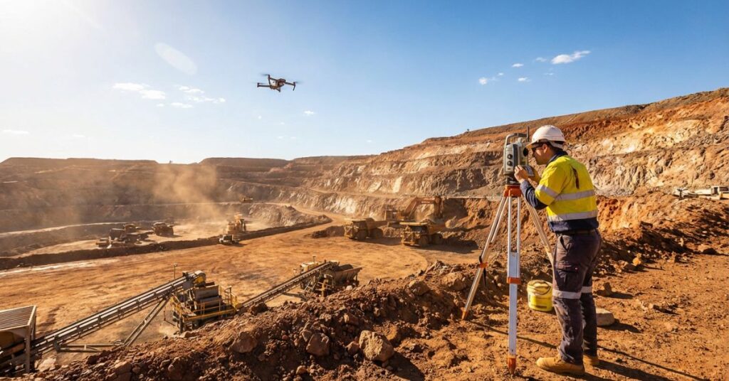
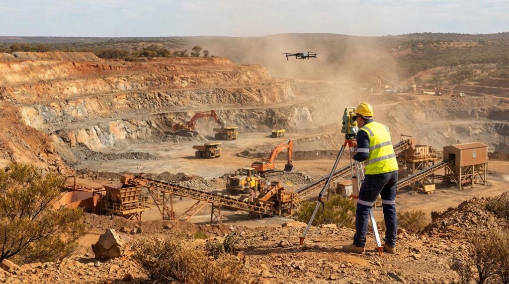
Nowadays, the mining project surveying has taken a different form. Surveyors can now work in the field revolutionized by drones, LiDAR (Light Detection and Ranging), and photogrammetry.
Rather than wasting days on foot surveying rugged terrain, mining surveyors in Australia today take a few minutes to drone-fly and obtain high-resolution aerial shots. These drones deliver high-resolution 3D maps and volumetric data, which enable more accurate pit design, stockpile calculations, and progress tracking.
Drones will be able to access areas too hazardous for human surveyors under challenging situations, boosting efficiency and safety. This technology, coupled with advanced software, helps mining companies make decisions faster than ever.
At 2Survey, we are the experts in deploying these innovative drone surveying solutions to deliver high-precision outcomes for intricate mining activities.
The importance of the Mining Project Survey
The history of mining surveying is not merely an Omnibus Technology History, but what that technology makes possible.
Modern engineering surveying in Australia assists throughout the entire lifecycle of the mining business, from exploration and feasibility studies to rehabilitation and closure.
And this is why proper surveying is essential to all stages:
Exploration & Planning: Surveyors map the area and its geological features to identify potential resource locations.
Design & Construction: Accurate measurements will be used to construct roads, pits, and tunnels.
Operations & Monitoring: Continuous surveys ensure projects are compliant, efficient, and safe.
Rehabilitation: During mine closure, surveyors provide key information to restore the environment.
In a nutshell, mining project surveying ensures that all mining processes are efficient, economical, and in compliance with the stipulations.
The Human Touch: Knowledge behind the Technology
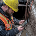
Although efficiency depends on technology, expertise remains the most critical value. Australian mining surveyors, including surveyors Melbourne supporting interstate mining operations, provide practical, actionable information based on decades of field experience and modern tools.
This combination of human intelligence and technological accuracy is our strong point at 2Survey. It is either a massive open-pit mine or a ground-level operation, we will carry with us a team spirit that goes hand in hand with the engineering, construction and project management team.
The Future of Mining Surveying Smarter, Safer, Sustainable
In the future, surveying for mining projects will be further developed through artificial intelligence (AI), automation, and real-time data analytics. Intelligent drones will soon enable autonomous flight paths, real-time terrain scanning, and the detection of dangerous objects.
Not only will these innovations improve productivity, but they will also minimize environmental impact, aligning with the increased attention to sustainable mining practices in Australia. This is because 2Survey is already investing in these next-generation technologies as an industry leader, keeping its clients ahead of the curve.
Final Thoughts: Precision That Powers Progress
From compass-wielding explorers to drone-equipped professionals, the journey of mining project surveying reflects the broader evolution of Australia’s mining industry — bold, innovative, and always forward-thinking.
As technology advances, one thing remains constant: the need for precision and expertise. Whether you’re developing a new mine or upgrading existing infrastructure, accurate surveying is the foundation of success.
At 2Survey, we combine cutting-edge technology with deep industry knowledge to provide reliable engineering surveying in Australia and world-class mining project surveying solutions.
Looking for experienced mining surveyors in Australia who understand both the technical and practical sides of your project? Contact 2Survey Today to discuss your mining or engineering surveying needs. Let’s map your project’s success, from the surface to the seam.
Frequently Asked Questions
1. What does a mining surveyor do?
A mining surveyor measures, maps, and monitors mine sites to support planning, excavation, construction, safety, and environmental compliance.
2. Why is surveying important in mining projects?
Surveying ensures accurate mine design, safe operations, efficient resource extraction, and proper environmental rehabilitation during and after mining.
3. What technology is used in modern mining surveys?
Surveyors now use drones, LiDAR, GPS, total stations, 3D modelling, and GIS to collect precise, real-time data for mine planning and monitoring.
4. How often should mining sites be surveyed?
It depends on project size and activity, but active mines typically require regular surveys—weekly, monthly, or at every major construction or excavation stage.
5. What are the main challenges in mining surveying?
Surveyors often face difficult terrain, remote locations, environmental hazards, and the need for high accuracy under constantly changing site conditions.