Every efficient development project begins long before the bulldozers and construction crews arrive. It starts with sound information about the land itself. Homes, shops, and infrastructure cannot be built without accurate information regarding the property’s limits, topography, and conditions. Access to this information facilitates the completion of the project. Otherwise, the risk of costly delays, conflicts, and disruptive errors is greater. Surveyors Melbourne provide this critical information, ensuring projects start on solid ground.
This is where land development surveyors play a key role in the development process, as they provide a democratic framework of respect for the tasks ahead of the developer. Regardless of the project’s size, whether large or small, we can be assured that it is progressing with focus and importance to its development.
A development project based in Alice Springs, with its vast, unique, and potentially varied natural landscapes, emphasises the importance of local knowledge and technical skills in planning and delivering development projects in the Red Centre.
Surveyors in Alice provide the knowledge of local geospatial imperatives and skills to survey infrastructure development, ensuring they will integrate the formal style and planned output of development into the unique natural landscape.

1. Defining Boundaries: Preventing Costly Disputes
One key duty of land development surveyors is to define property boundaries. In the broadest terms, this means determining where one parcel of land ends and the next begins, which is a relatively simple task; however, these boundaries have initiated numerous disputes over the years, resulting in significant time and financial costs.
Professional surveys clearly outline property lines to a legal standard. Clarity on boundaries assures builders, giving them certainty about where they can build and avoiding the complications of possible litigation or the need to demolish a building that may infringe on someone else’s property.
In Alice Springs and areas where land parcels may have non-conventional shapes, are remote, or have a history, defining accurate boundaries is even more important. Surveyors in Alice Springs area can determine and mark where overlays will be in place and boundaries in challenging terrain, and will position local projects on solid ground.
2. Site Analysis: Understanding Topography and Features
Each piece of land is different. In addition to boundaries, there are slopes, soil types, plant growth, drainage, and subsurface utilities to consider. A complete site analysis by land development surveyors takes all this critical data.
By gathering precise information on natural features and topography, surveyors provide architects and engineers with the data they require to produce feasible and realistic designs.
For Alice Springs developers, site analysis calls for additional expertise. The Red Centre’s unique conditions, e.g., sandy soils, desert flora, and flooding from seasonal rains, require local knowledge. Surveyors in Alice Springs provide that insight, supporting projects to prosper in conditions that outsiders might be intimidated by.
3. Enabling Informed Planning and Design
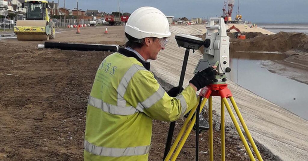
Land development surveyors’ data is the guidebook for project development. Contemporary surveyors rely on sophisticated tools, such as drones, GPS technology, and 3D mapping applications, to prepare extremely accurate site maps. These enable developers and designers to have full clarity regarding the land they are dealing with, eliminating guesswork and expensive redesigns.
With precise survey information, planners can anticipate and address issues before they arise. Fundamentally, professional surveys transform unconstructed land into a comprehensible canvas, enabling architects, engineers, and contractors to produce efficient and sustainable designs.
4. Adhering to Legal and Environmental Regulations
All development projects are subject to strict legal and environmental regulations. There are governing guidelines from local councils and government agencies to ensure safety, sustainability, and preservation of protected zones. Once again, land development surveyors are extremely useful in this context.
Surveyors locate easements, zoning ordinances, and heritage or conservation zones that can influence the use of a property. Regulation compliance is especially crucial in Alice Springs, where cultural and environmental sensitivities are at stake. Subdivisions in the Red Centre must consider Aboriginal land rights, archaeological sites, and sensitive desert ecosystems.
Working with surveyors in Alice Springs ensures projects remain compliant with both legal standards and environmental protections, avoiding penalties and delays.
5. Mitigating Risks and Identifying Hazards Early
One of the most practical advantages of professional surveys is risk management: development is an ongoing investment, and unexpected issues on site can be costly in terms of time, money, and safety. Land development surveyors help identify risks before construction even begins.
Not only do they identify these risks early, but they also provide project teams with adequate time to consider how to address them, such as modifying designs, increasing structural integrity, and adjusting schedules.
Local surveyors, who are well-acquainted with the risks of extreme weather and desert conditions in places like Alice Springs, are particularly adept at identifying these potential issues early in the project. This foresight and knowledge greatly reduce the potential disruption to the project, providing invaluable information and data at every step of the process.
6. Maximising Land Use and Property Value
A professional land survey helps to identify opportunities and eliminate problems. The essential role of an accurate survey is to provide developers with legitimate data related to maximising every square metre of land. That could be the best placement of buildings, strategic and efficient subdivisions, or generating space for community parks and roads.
Land surveys effectively add value to a site. Surveys aid in the design and efficient use of space, resulting in revenue-generating, productive land use.
Surveyors in Alice Springs play a crucial role in projects within the local region by ensuring land value is maximised in both urban and remote areas, supporting the appropriate development of spaces as Alice Springs grows and beyond.
7. Supporting Conflict Resolution and Clear Transactions
Land surveyors are invaluable to land development, providing protection of property rights and facilitating transactions. Surveyors secure documentation to record ownership boundaries and land conditions, often acting as proof in legal matters when disputes arise.
In Alice Springs, specifically, where property is often valued beyond its replacement cost, the necessity for clarity is crucial. Surveyors in Alice Springs are always acting in almost any role possible to create certainty within property transactions and local agreements.
Why Professional Surveys are Needed for All Projects?
In unique places like Alice Springs, which boasts a demanding landscape and great potential, the role of a professional surveyor is highly relevant. Local knowledge combined with technical capabilities to ensure that a development project will not only occur but will flourish through better engagement with the environment and community.
Ultimately, land development surveyors can be more than just experts in technical matters. They are the foundation builders for every project. As a surveyor’s foundation provides clarification, security, and opportunity, it often unlocks the entire outcome of a parcel of land or a project, providing an opportunity for all parties involved.
For accurate, efficient survey, contact 2Survey now! Your land deserves error-free survey!
Frequently Asked Questions
A land development survey maps boundaries, features, and site conditions so builders and planners can design and develop land safely and legally.
Alice Springs has unique terrain, cultural areas, and desert conditions, so surveys ensure accurate boundaries, safe design, and full compliance with local regulations.
Surveyors mark legal property lines clearly, helping avoid disagreements, construction mistakes, and costly legal issues.
It includes boundaries, topography, soil, drainage, site features, utilities, easements, zoning, and any environmental or cultural constraints.
Accurate survey data lets architects and engineers design correctly from day one, spotting hazards early and preventing expensive delays or redesigns.